קובץ:Uruk Archaeological site at Warka, Iraq MOD 45156521.jpg

גודל התצוגה המקדימה הזאת: 800 × 531 פיקסלים. רזולוציות אחרות: 320 × 213 פיקסלים | 640 × 425 פיקסלים | 1,024 × 680 פיקסלים | 1,280 × 850 פיקסלים | 3,000 × 1,993 פיקסלים.
לקובץ המקורי (3,000 × 1,993 פיקסלים, גודל הקובץ: 4.12 מ"ב, סוג MIME: image/jpeg)
תקציר
| תיאור |
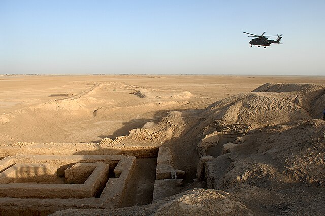
 English: A general view of the Uruk archaeological site at Warka in Iraq.
The site of Uruk was discovered in 1849 by William Kennett Loftus who led the first excavations from 1850 to 1854. The Arabic name of Babylonia, al-ʿIrāq, is thought to be derived from the name Uruk, via Aramaic (Erech) and possibly Middle Persian (Erāq) transmission.
|
| תאריך יצירה | |
| מקור | |
| יוצר | SAC Andy Holmes (RAF) |
| אישורים והיתרים (שימוש חוזר בקובץ זה) |
Images are downloadable at high resolution, made available at http://www.defenceimagery.mod.uk for reuse under the OGL (Open Government License). |
| מיקום המצלמה | | תמונה זו ותמונות נוספות במיקום: OpenStreetMap |
|---|
רישיון
.svg)
|
This file is licensed under the Open Government Licence version 1.0 (OGL v1.0).
|
|---|---|
| ייחוס:Photo: SAC Andy Holmes (RAF)/MOD | |
|
You are free to:
See the Open Government Licence page on Meta-Wiki for more information.
|

|
This file was generated using equipment from Wikimedia UK, a Wikimedia local chapter.
|
היסטוריית הקובץ
ניתן ללחוץ על תאריך/שעה כדי לראות את הקובץ כפי שנראה באותו זמן.
| תאריך/שעה | תמונה ממוזערת | ממדים | משתמש | הערה | |
|---|---|---|---|---|---|
| נוכחית | 22:40, 10 במרץ 2014 | | 1,993 × 3,000 (4.12 מ"ב) | Fæ | == {{int:filedesc}} == {{information |description={{en|A general view of the Uruk archaeological site at Warka in Iraq. The site of Uruk was discovered in 1849 by William Kennett Loftus who led the first excavations from 1850 to 1854. The Arabic nam... |
שימוש בקובץ
הדף הבא משתמש בקובץ הזה:
שימוש גלובלי בקובץ
אתרי הוויקי השונים הבאים משתמשים בקובץ זה:
- שימוש באתר cs.wikipedia.org
- שימוש באתר cv.wikipedia.org
- שימוש באתר da.wikipedia.org
- שימוש באתר de.wikivoyage.org
- שימוש באתר es.wikipedia.org
- שימוש באתר fa.wikipedia.org
- שימוש באתר fi.wikipedia.org
- שימוש באתר fr.wikipedia.org
- שימוש באתר hr.wikipedia.org
- שימוש באתר hu.wikipedia.org
- שימוש באתר hy.wikipedia.org
- שימוש באתר incubator.wikimedia.org
- שימוש באתר io.wikipedia.org
- שימוש באתר it.wikipedia.org
- שימוש באתר ja.wikipedia.org
- שימוש באתר lt.wikipedia.org
- שימוש באתר lv.wikipedia.org
- שימוש באתר nl.wikipedia.org
- שימוש באתר pl.wikipedia.org
- שימוש באתר ro.wikipedia.org
- שימוש באתר uk.wikipedia.org
- שימוש באתר war.wikipedia.org
- שימוש באתר zh.wikipedia.org